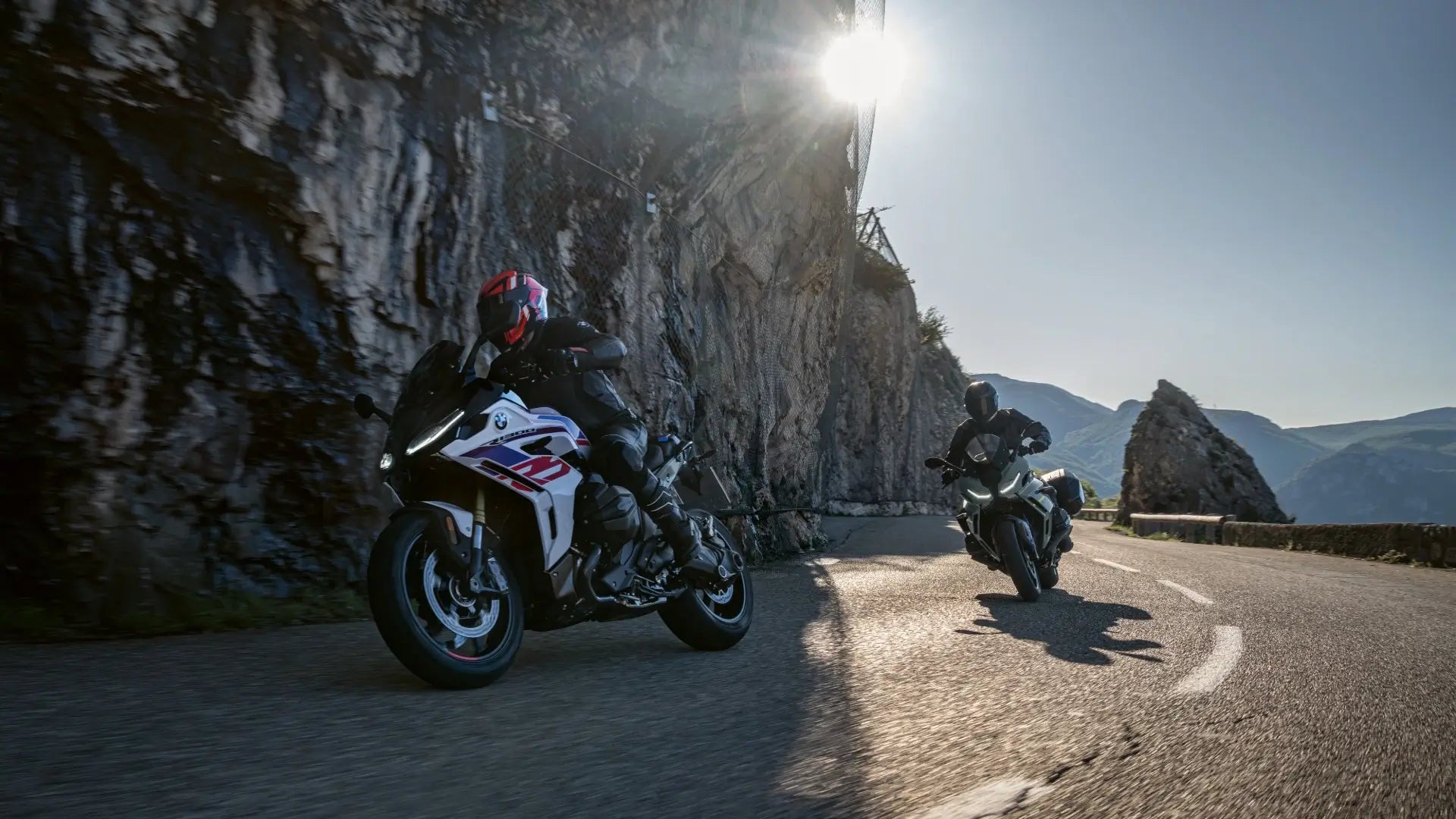
Riding a BMW GS is a particular kind of freedom. These bikes are made for long miles, loaded luggage, and an honest bite of unpaved dirt when the road calls for it. For many riders, a great route is the difference between a good weekend and a trip you’ll tell stories about for years. This guide picks five of the most scenic, GS-friendly routes in the United States, then walks you through planning, gear, navigation tools, safety, and sample itineraries. If you want to ride the “best motorcycle roads for BMW GS,” you’ll find the practical detail you need here.
Quick preview — the Top 5 routes
-
Pacific Coast Highway (CA-1) — classic sea-to-cliff coastal miles and Big Sur vistas.
-
Blue Ridge Parkway + Cherohala Skyway / Smokies — rolling mountain sweepers and fall color.
-
Tail of the Dragon (US-129, Deals Gap) — short, technical, legendary twisties.
-
Beartooth Highway (US-212) — alpine passes, dramatic vistas, and seasonal thrills.
-
Million Dollar Highway / San Juan Skyway (US-550) — steep switchbacks, high passes, and mining towns.
Each route offers a different flavor of riding — from coastal cruising to alpine sweepers to tight technical roads — and each suits the BMW GS in its own way: comfortable on long pavement stretches and capable enough for gravel and rougher surfaces when needed.
Why these rides suit a BMW GS
The GS family is built around versatility. Long suspension travel, upright ergonomics, a capable touring range for luggage, and options for either tubeless or tubed wheels make GS bikes a natural choice for mixed routes. These five rides reward a GS in three ways:
-
They demand endurance and comfort for long days. A GS’s seat, ergonomics, and fuel range help you eat miles without destroying your body.
-
They include sections where adventure capability matters — short gravel legs, mountain passes, or secondary roads — and the GS does those without drama.
-
There are many services and fuel stops on or near these routes, which matters when you’re carrying gear and need predictability.
I’ve ridden parts of these routes and planned many GS trips for friends. Practicality matters more than poetry when the sun’s setting and the next fuel stop is 90 miles away. That’s what you’ll get here: a balance of inspiration and logistics.
Route 1 — Pacific Coast Highway (CA-1): long vistas, slower rhythm

Image credit: visit california
What makes it special
The Pacific Coast Highway (CA-1) is cinematic for a reason: sheer cliffs drop to surf, redwoods backcountry breathes, and the coastal line unspools picture after picture. For GS riders, the PCH is an ideal blend of long, flowing pavement and casual sightseeing stops. It’s also forgiving — lots of services, easy access points, and options to shorten or extend your ride.
What to expect
-
Road character: Mostly smooth pavement; occasional narrow shoulders and blind corners—especially through Big Sur. Expect tourist traffic at viewpoints and in small towns.
-
Amenities: Good fuel and lodging frequency, but Big Sur and some coastal stretches have limited services — plan fuel and food stops.
-
Best time: Spring through early fall. Summer is reliable for clear days, but coastal fog can arrive even in summer mornings.
BMW GS tips for PCH
-
Use a medium-height windscreen to reduce buffeting.
-
Fit touring tires if you’ll average long highway miles.
-
Pack a light rain shell — local microclimates can be damp.
Route 2 — Blue Ridge Parkway + Cherohala Skyway / Smokies: gentle drama and colors

Image credit: smoky mountain rider
What makes it special
The Blue Ridge Parkway is built to be savored: sweeping ridgelines, thoughtful overlooks, and a slower pace. Pair it with the Cherohala Skyway or the Smoky Mountains roads and you get more technical curves, remote campsites, and mountain air. The National Park Service posts specific guidance for motorcycle riders — single-file riding and measured speeds make these roads safer and more enjoyable.
What to expect
-
Road character: A mix of relaxed sweepers and shorter technical sections. Expect scenic pullouts and lower speed limits on the Parkway.
-
Best time: Late spring through early fall; fall color (mid-September to November depending on elevation) is spectacular but busy.
BMW GS tips for the Parkway and Cherohala
-
Ride single file through narrow curves and respect pullout spaces for photographers.
-
Suspension set-up: a neutral touring setting keeps the GS composed at the Parkway’s lower speeds.
-
When you head into Cherohala: carry a small tool kit and emergency supplies — remote stretches can be sparse.
Route 3 — Tail of the Dragon (US-129, Deals Gap): legendary twisties

Image via Facebook
What makes it special
Tail of the Dragon is a short, intense playground: 11 miles and roughly 318 curves. It’s iconic and adrenaline-charged. It’s also highly technical, and weekend crowds can be heavy.
What to expect
-
Road character: Tight turns, rapid direction changes. Not the place for heavy luggage or a steep learning curve. Watch for mixed traffic — sportbikes, cars, and rental vehicles.
-
Best time: Weekdays or early mornings to avoid crowds; spring through fall for best weather.
BMW GS tips for Deals Gap
-
If you bring a GS, lighten the bike: remove nonessential luggage and lower weight.
-
Warm your tires before pushing pace. The surface is generally good but gravel/debris can collect near the edges.
-
Consider a recon run at a conservative pace before pushing — safety first.
Route 4 — Beartooth Highway (US-212): alpine vistas and seasonal windows

Image credit:Getty Images
What makes it special
The Beartooth Highway climbs into an alpine world: snowbanks that linger into summer, high meadows, and sweeping plateaus. Riding the “Top of the World” is a trophy for many riders. The highway is seasonal and opens around Memorial Day weekend through mid-October depending on weather, so plan around DOT postings.
What to expect
-
Road character: Paved, narrow in places, high elevation. Expect rapid weather changes and occasional rockfall warnings.
-
Season: Usually open from Memorial Day weekend through mid-October, weather permitting — confirm local DOT updates before you go.
BMW GS tips for Beartooth
-
Watch the altimeter and your own energy — high elevation affects people and machines.
-
Layered clothing is essential; temps change fast.
-
Keep fuel topped off and know where the next town or ranger station is.
Route 5 — Million Dollar Highway / San Juan Skyway (US-550): remote alpine mining roads

*San Juan Skyway. Photo by Jason J. Hatfield
What makes it special
The Million Dollar Highway is dramatic: narrow lanes, steep dropoffs, and switchbacks that demand respect. The full San Juan Skyway loop gives a broader experience: mining towns, hot springs, and alpine vistas. It’s beautiful, but pay attention to shoulders and weather.
What to expect
-
Road character: Steep climbs, narrow shoulders on old highways, limited guardrails in some places. Ride cautiously.
-
Best time: Summer into early fall, with late September often offering peak aspen color. Check road conditions before you go.
BMW GS tips for Million Dollar Highway
-
Brakes and cooling are critical here; long descents can test braking systems.
-
Plan fuel stops in Durango or Silverton — remote stretches have limited services.
-
Consider staggered arrival times for photo stops; the road can get busy.
Off-pavement & extended adventure options
If your GS is an off-road variant or you want to add longer gravel legs, Backcountry Discovery Routes (BDR) and the Trans-America Trail (TAT) offer curated gravel tracks that pair well with GS bikes. BDR provides GPX tracks, resupply info, and planning resources — ideal if you want real off-pavement challenge.
Seasons, closures, and why you must check official sources
Mountain passes and scenic byways often have strict seasonal windows and sometimes vehicle restrictions. The Beartooth Highway, for example, has a defined open season and can close unexpectedly for weather; DOT and NPS pages are the authoritative source for openings. Likewise, the Blue Ridge Parkway posts specific motorcycle safety advice and rules you should follow. Always check official state DOT or National Park Service pages within 48 hours of departure.
How to plan — a step-by-step checklist
1. Choose your season and route windows
Match the route to seasonal openings. High alpine passes = summer; coastal = spring-fall; autumn = leaf color for mountains.
2. Daily mileage and realistic pacing
Plan comfortable daily miles. GS bikes let riders run longer days, but fatigue crushes fun. For scenic routes, 200–300 miles per day with frequent stops keeps you fresh.
3. Navigation & GPX
Export GPX tracks from trusted sources: Butler Maps for curated scenic loops, REVER for community routes and mobile tracking, and BDR for off-pavement lines. Load GPX to a proper motorcycle GPS (Garmin Zumo series, or a rugged phone mount with offline maps).
4. Lodging vs camping
Alternate nights or lock in lodgings in busier stretches. Camping is great for solitude, but a secure hotel night resets you for long mountain days.
5. Food and fuel plan
Identify towns with fuel and mark them on your GPX. Mountain areas often have long gaps between services.
Gear, tires, and bike prep (BMW GS focus)
Tires
-
For mostly paved, choose a long-mile sport-touring or adventure-touring tire (good wet grip matters on coastal and mountain roads).
-
For mixed gravel, step to a 70/30 or 50/50 adventure tire.
Suspension & maintenance
-
Set sag for the loaded condition. A GS with luggage benefits from slightly softer rear preload for comfort.
-
Check brakes, chain or shaft drive, and fluid levels. Carry a compact tire inflator and basic tool kit.
Luggage
-
Hard panniers offer security and weather protection; soft bags save weight. Consider a small tank bag for quick access items.
Safety & communication
-
Bluetooth comms for navigation prompts and rider-to-rider chat. Carry a power bank and a GPS tracker for remote trips.
Sample itineraries (ready to adapt)
7-day PCH sampler (start San Francisco) — highlights + daily mileage
Day 1: SF → Santa Cruz → Monterey (100–150 miles).
Day 2: Monterey → Big Sur → San Simeon (150–200 miles; slow scenic section).
Day 3: San Simeon → Morro Bay → SLO → Cambria (shorter day).
Day 4: Cambria → Santa Barbara (170–200 miles with stops).
Day 5: Santa Barbara → Ventura → Malibu → Santa Monica (urban coast; watch traffic).
Day 6: L.A. → San Diego coastal options (200+ depending on loops).
Day 7: San Diego local loop and depart.
10-day Mountain loop (Denver base)
Day 1: Denver → Durango.
Day 2: Durango → Silverton → Ouray (Million Dollar Highway sections).
Day 3: Ouray → Telluride → Gunnison.
Day 4: Gunnison → Grand Junction → Moab (diversion).
Day 5: Moab rest day (Arches/Canyonlands).
Day 6: Moab → West Yellowstone.
Day 7: West Yellowstone → Cooke City → Beartooth Pass.
Day 8: Beartooth → Cody → Jackson Hole.
Day 9: Jackson Hole → southern loop home.
Navigation apps and mapping tools (practical picks)
-
Butler Maps — curated, rider-tested paper and digital maps. Great for finding the best twisties.
-
REVER — route building, offline modes, and a big library of user rides. Useful for exporting GPX and tracking on the road.
-
BDR — download official Backcountry Discovery Route tracks for off-pavement legs.
Safety checklist (must-do before you roll)
-
Share your route and check-in times with someone at home.
-
Make sure your phone and GPS have offline maps and battery power.
-
Print or screenshot the most remote gas towns and phone numbers.
-
Check NPS / DOT pages within 48 hours of departure for closures.
Real rider lessons (experience)
From planning and guiding GS rides, these lessons matter more than perfect packing:
-
Start easy the first day so the bike and you adapt to loaded dynamics.
-
Hydrate and eat frequently — it’s easy to fall into “ride longer, eat less” trap.
-
Respect local speed and lane rules — police and locals enforce limits on scenic roads.
-
Local intel beats the map — ask a ranger or gas attendant about recent rock slides or wildlife on the road.
Quick Q&A
Q: When is the best season to ride these routes?
A: Coastal routes: spring–fall. Alpine passes (Beartooth, San Juan): summer–early fall when roads are open. Always confirm on DOT or NPS sites.
Q: Do I need special tires for a GS?
A: Depends on your route mix. Mostly pavement = sport-touring/adventure-touring tires. Expect gravel? Move to a 50/50 or 70/30 adventure tire.
Q: Are guided tours worth it?
A: For first long trips or if you want zero logistics, yes. Many operators include support vehicles and local knowledge.
Sources & further reading
(Bookmark these official and trusted planning resources before you go.)
-
Beartooth Highway (Montana DOT) — seasonal opening info and road advisories. mdt.mt.gov
-
Blue Ridge Parkway — motorcycle safety & rules (National Park Service). US National Park Service
-
Tail of the Dragon (Deals Gap) official materials and visitor info. Tail of The Dragon
-
Pacific Coast Highway rider guides and route notes. pashnitdairylandinsurance.com
-
Million Dollar Highway / San Juan Skyway guides and ride tips. Ride to Fooddairylandinsurance.com
-
Backcountry Discovery Routes (BDR) — free GPX tracks and planning tools for off-pavement routes. Backcountry Discovery Routes
-
Butler Maps — curated motorcycle road maps and route suggestions. Butler Maps
-
REVER — motorcycle trip planner and route sharing. rever.co
-
National Park Service — motorcycle safety articles and guidance. US National Park Service
Closing: ready to plan your GS adventure?
If you want, I’ll build a custom 7–10 day itinerary for your start city and travel window, including daily mileages, suggested fuel/lodging stops, and an exportable GPX pack for your GPS. Tell me your start city, travel dates (approx.), and whether you prefer campsites or hotels — I’ll draft a route tuned for your BMW GS.
Related Article
Top BMW Motorrad Error Codes: What They Mean and How to Fix Them
The Best BMW Motorrad OBD2 Scanner: CGSULIT SC530 Pro vs Hex GS-911?